We offer a selection of routes to make your stay in our accommodations more enjoyable.

1-Guazalamanco Stream – Bolera reservoir.

Starting from our accommodation we will head towards Pozo Alcón, from there towards the Bolera reservoir-Castril-Huescar, in about 8 km we will arrive at the Bolera campsite, about 500 m further on we will find a sign that says El Hornico and Guazalamanco stream, we take a path to the left.
We set the odometer to zero and in approximately 6 km we find a cement ramp on the left, we leave our vehicle and begin the route on foot, going up the ramp and following the path until we find the stream, we continue walking until we find an artificial waterfall and we retrace our steps to the Bolera reservoir where we can walk around the dam and surroundings, we recommend visiting the Alcantarilla and Peña Quesada viewpoints.
2-Footbridge over the Castril River and Portillo Reservoir. Castril PDF


From our accommodations and following Route 1 (Guazalamanco Stream) to the Bolera Reservoir, we continue along this same road to the village of Castril. Before reaching the village, we come across the Portillo Reservoir, where we stop to walk, stretch our legs, and admire this beautiful reservoir. We set off and after about 2 km we reach the village. After passing the gas station, we turn right, and at the first street we turn right again. This road will take us to the river. We leave our vehicle on the left when we reach the river and begin the route walking through La Arboleda Perdida. We reach a wooden walkway over the riverbank. We continue walking until we reach a suspension bridge over the river. Upon crossing this, we come across a tunnel. We pass through it, and once outside, we rest before returning to our vehicle.
3-Water Cave-Tiscar Sanctuary and Zabaleta Museum.

From our accommodation, head towards Pozo Alcón-Huesa. Without entering Pozo Alcón, continue towards Huesa. After a gas station, turn left towards Quesada. We’ll travel about 14 km of winding curves, but on a good road surface until we reach the site. Before reaching Tiscar, we’ll find a sign on the left that tells us «Cueva del Agua.» A little further on, we can also visit the Tiscar sanctuary, and we can finish the route by continuing to the town of Quesada and visiting the Zabaleta Museum.
UTM coordinates of the Tiscar Sanctuary: x = 498035; y = 418043. Water Cave: x = 498025; y = 4180295.
4-Zújar Baths
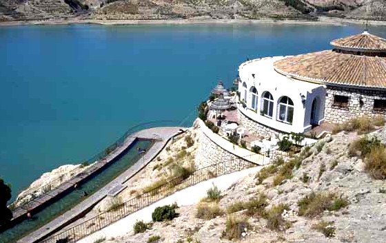
From our accommodation, we head towards Zújar. Once there, we cross the town and follow this same road for about 10 km. It will take us to a circular restaurant located on the left side of the road. The thermal pool is located below the restaurant, above the Negratín reservoir.
The pool is about 30 m long and 3.5 m wide. It is partially covered in winter and admission is about €2 for the whole day.
5-Negratín Viewpoint. Negratín Chimneys Route.


Don’t miss this impressive viewpoint, where you can admire the Negratín gullies, the reservoir, and the Sierra Nevada in the background. To get there from Cuevas del Campo, head toward Zújar. After about 3 km, you’ll see a sign to turn left near the Negratín restaurant. The Negratín Chimneys route, in the heart of the Granada Geopark, departs from the viewpoint and is a circular route that takes approximately 2 hours. Route on Wikiloc


6-Nacimentos de Peralta- Enchanted forest of fig trees.


We leave Pozo Alcón heading towards Castril, and pay attention to a sign on the right indicating an intensive fishing reserve. When we reach the river, we go up to the dam and return. Along the way, we find the water sources among lush vegetation.
7-Negratín Cathedrals Route, Granada Geopark. Route on Wikiloc


A paradise in the Granada Plateau.
Unique Experiences

Incredible places, the Enchanted Fig Forest, Guazalamanco, perfect places to enjoy nature and outdoor activities.

The places are incredible, with water everywhere, and the reservoir is simply spectacular. 100% recommended!